
ΔΕΙΤΕ ΚΑΙ ΤΟΝ ΣΥΝΔΕΣΜΟ!

It seems that indeed the lake-cave of Melissani with its running water flow was the entrance of the spirits towards the underworld in antiquity.


- ΗΡΘΕ Η ΩΡΑ ,,ΝΑ ΠΕΡΙΓΡΑΦΕΙ Η ΟΜΗΡΙΚΗ ΙΘΑΚΗ!! εν αρχη Αγγλικα
MELISSANI cave (karavomilos Sami Kefalonia)
On the Cave of the Nymphs in the Thirteenth Book of the Odyssey.
Homer’s description of the Cave of the Nymphs presents an almost photographic image, down to the last detail, of the dramatic lake cave of Melissani, in whose name we hear a loud echo of Homer’s ‘bees’ (μέλισσαι).
This cave is just a short distance inland from Sami Bay, Homer’s ‘harbour of Phorkys’, which is marked on early maps of Kephallenia as Fochi or Fochi or Focchi (Φόρκυ = Forchi).In very ancient times the spirits of the deceased were called “Melisses” (transl.: bees).
In the study of the philosopher Porfyrios (234-304 A.D.) regarding the Homeric cave of the nymphs with the title “Περί του εν Οδύσσεια των νυμφών άντρου” we read that the springs and the clear waters were related intimately with the water nymphs and of course they were even more intimately related with the nymphs-spirits who were called “melisses” in very ancient times.
In 1963 the archaeologist Spyridon Marinatos did an archaeological research in the cave of Melissani. The archaeological finds of this research proved the relation between the Naiaden nymphs with this specific cave. (see the photos beside of the plaques with the Naiaden nymphs that were found in the central sacrificial area of the cave).
It seems that indeed the lake-cave of Melissani with its running water flow was the entrance of the spirits towards the underworld in antiquity.
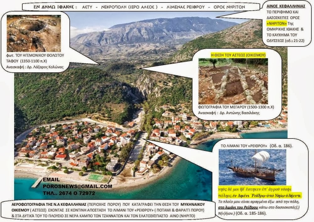
THE HARRBOUR OF RHEITHRON
"the port of Homeric Ithaka"
Homer says that the ὑπονήιος area was ‘the harbour of Rheithron’ (or ‘the harbour of the river bed’) just outside the city:
τὸν δ᾽ αὖτε προσέειπε θεά, γλαυκῶπις Ἀθήνη·
"τοιγὰρ ἐγώ τοι ταῦτα μάλ᾽ ἀτρεκέως ἀγορεύσω.
Μέντης Ἀγχιάλοιο δαΐφρονος εὔχομαι εἶναι
υἱός, ἀτὰρ Ταφίοισι φιληρέτμοισιν ἀνάσσω.
νῦν δ᾽ ὧδε ξὺν νηὶ κατήλυθον ἠδ᾽ ἑτάροισιν
πλέων ἐπὶ οἴνοπα πόντον ἐπ᾽ ἀλλοθρόους ἀνθρώπους,
ἐς Τεμέσην μετὰ χαλκόν, ἄγω δ᾽ αἴθωνα σίδηρον.
νηῦς δέ μοι ἥδ᾽ ἕστηκεν ἐπ᾽ ἀγροῦ νόσφι πόληος,
ἐν λιμένι ῾Ρείθρῳ ὑπὸ Νηίῳ ὑλήεντι.(Od. 1.178-186)
‘I will answer all your questions truthfully,’ answered the bright-eyed goddess Athena. ‘I declare that I am Mentes, the son of warlike Anchialos, and I rule over the seafaring Taphians. And now I have arrived here with my ship and crew, sailing across the wine-dark sea to Temese where the people speak a strange language, carrying gleaming iron to exchange for copper. My ship lies over there beside the fields away from the city, in the harbour of Rheithron, below wooded(?) Neïon.’
The word ῥεῖθρον rheithron (ῥέεθρον), used to describe the physical setting of the port of Homeric Ithaka, is derived from the verb ῥέω (to flow) and its other derivatives: ῥεῖθρα, ῥεῦμα, ποτάμια ῥεῖθρα (river bed), ῥύαξ, etc. So Homer indicates very clearly that the port of Homeric Ithaka was situated in a river
bed.How important is it for researchers to verify this information – an item of information unique in Homer’s epics? To put it another way, in trying to locate the city and palace of Homeric Ithaka, how helpful would it be to establish whether or not a harbour in a river bed, as described by Homer, actually existed?
Have any ancient harbours in river beds been found on Kephallenia, and more specifically in the part of Kephallenia under discussion: the south-east?
Archaeological finds have proved that in antiquity there were at least two harbours in river beds on Kephallenia, both of which can be located with a fair degree of certainty. One is at Vatsa at the south end of the Paliki peninsula, where a sanctuary of Poseidon has been discovered, and the other is on the east coast of the island, in the bed of the River Vohynas at Poros. In the Mycenaean period the sea here reached almost as far as the modern flood barrier. In historical times the silt and rubble brought down by the river pushed the shoreline out to where the stone bridge now stands: there the ancient harbour works and archaeological finds dating from the Hellenistic period were found when the bridge was being built. Since then, and especially since the 1953 earthquakes, the ground level has risen by about one and a half metres, with the result that the water in the river bed has receded considerably. In 1936 the government of Ioannis Metaxas had the ancient harbour filled in because the mosquitoes breeding in the stagnant water were a permanent health hazard to the local people. Since then most of the floor of the ancient harbour has been used every summer as a car park! (see photograph).
Here, then, we have a striking and rare peculiarity: the ancient port of the Pronnaians was on the banks and in the bed of a river – the seasonal River Vohynas, which flows through the scenic Poros gorge and out into the eastern Ionian Sea (see photograph) – just like Ithaka’s ‘harbour of Rheithron’ as described by Homer.
Charles Napier, the Resident in Kephallenia under the British Protectorate, described this magnificent landscape as follows:
Description of the district of Aracli, or Heraclea
Before the river reaches the sea, it passes through a narrow chasm in the eastern ridge, whose rocky sides rise perpendicularly to a vast height above the bed of the river, which is strewed with large masses that have fallen from above, where many still overhang, and threaten to crush the passing traveller. These great rocks form the base of two mountains, covered with wood, which stand on each side, like sentinels, to guard the entrance of this beautiful valley. On the southern height are extensive Cyclopian ruins.… On passing this rocky defile, there is a small plain between it and the sea, and enclosed by the rocks, which run down on each side to the water’s edge. On crossing the rocks, to the south, you find the beautiful little port of Poros, formed by a jut of land, called ‘the Saracen’s landing place’.
Such is the valley of Heraclea, bounded by huge mountains, on whose precipitous sides, woods, rocks, and ruins, are profusely heaped in magnificent confusion.
Eastern outlet of the valley of Racli – Cefalonia 16th May 1832.
The fitting portal has this beautiful vale- and as singularly formed as most that was seen. The stream for ages winding its course to the sea, has worn away a duly narrow channel, when in the dry season, it settles in clean emerald pools of a great dept, but after it rains is converted again into a furious roaring current, boiling along in its dark bed and carrying earth and stones and opposes its course – The graceful (….) here attaining a height of 20 to 30 feet does not forsake the stream when it quits that ‘happy valley’, but accompanies it to the edge of the sea.
This pass in some places is not much above a dozen yards broad within side xx steps and lofty rock – those on the left, in this view bear on their summits a tale of ancient days in the cyclopean remains of The Hellenic city of Pronos – the remains of whose gigantic walls (….)to be well tread amid the thick tangled underwood – Pronos was one of the four large cities of Cefalonia, and share no remains to compare to Samos & Krani. Signora Cambici told me that the late resident of the island, Col. Napier had interested himself much in the explorations of these ruins, and discovered, or rediscovered what had been nearly might forgotten – They are situated in and out of the way, inaccessible place, and few persons visit them.
(This was written by H.L. Allen on the back side of the gravure)
Δεν υπάρχουν σχόλια:
Δημοσίευση σχολίου